ACCESS Cryosphere Community Datapool Tools (ccdtools)
This notebook provides a general introduction to the ACCESS Cryosphere Community Datapool Tools (ccdtools) and its functionality. This notebook is designed to be executed on the NCI Gadi supercomputer.
import ccdtools
import matplotlib.pyplot as plt
Initialise and interrogate the datapool catalogue
# Initialise the datapool catalogue.
## NOTE: To build a catalog on your local machine, parse a custom YAML file to ccdtools.catalog.DataCatalog(yaml_path = "<PATH_TO_YAML_FILE>").
catalog = ccdtools.catalog.DataCatalog()
# List all datasets within the catalog.
## NOTE:  A raw pandas.DataFrame can be returned using catalog.datasets
catalog
Number of datasets: 16
Rows: 65
| dataset | display_name | description | tags | version | subdataset | path | full_path | extension | skip_lines | no_data_value | ignore_dirs | ignore_files | loader | resolutions | static_patterns | |
|---|---|---|---|---|---|---|---|---|---|---|---|---|---|---|---|---|
| 0 | measures_bedmachine_antarctica | BedMachine Antarctica | High-resolution bed topography and ice thickne... | [antarctica, bed topography, ice thickness, su... | v1 | None | /g/data/av17/access-nri/cryosphere-data-pool/e... | /g/data/av17/access-nri/cryosphere-data-pool/e... | nc | 0 | NaN | [] | [] | default | None | [] |
| 1 | measures_bedmachine_antarctica | BedMachine Antarctica | High-resolution bed topography and ice thickne... | [antarctica, bed topography, ice thickness, su... | v2 | None | /g/data/av17/access-nri/cryosphere-data-pool/e... | /g/data/av17/access-nri/cryosphere-data-pool/e... | nc | 0 | NaN | [] | [] | default | None | [] |
| 2 | measures_bedmachine_antarctica | BedMachine Antarctica | High-resolution bed topography and ice thickne... | [antarctica, bed topography, ice thickness, su... | v3 | None | /g/data/av17/access-nri/cryosphere-data-pool/e... | /g/data/av17/access-nri/cryosphere-data-pool/e... | nc | 0 | NaN | [] | [] | default | None | [] |
| 3 | bedmap | Bedmap | Gridded, geospatial, and point datasets of Ant... | [antarctica, bed topography, ice thickness, su... | v1 | geospatial | /g/data/av17/access-nri/cryosphere-data-pool/e... | /g/data/av17/access-nri/cryosphere-data-pool/e... | gpkg | 0 | -9999.0 | [] | [] | default | None | [] |
| 4 | bedmap | Bedmap | Gridded, geospatial, and point datasets of Ant... | [antarctica, bed topography, ice thickness, su... | v1 | points | /g/data/av17/access-nri/cryosphere-data-pool/e... | /g/data/av17/access-nri/cryosphere-data-pool/e... | csv | 18 | -9999.0 | [] | [] | default | None | [] |
| ... | ... | ... | ... | ... | ... | ... | ... | ... | ... | ... | ... | ... | ... | ... | ... | ... |
| 60 | measures_its_live_regional_glacier_and_ice_she... | ITS_LIVE Regional Glacier and Ice Sheet Surfac... | ITS_LIVE regional glacier and ice sheet surfac... | [antarctica, greenland, ice velocity] | v2 | RGI17A | /g/data/av17/access-nri/cryosphere-data-pool/i... | /g/data/av17/access-nri/cryosphere-data-pool/i... | nc | 0 | NaN | [] | [] | measures_velocity | None | [_2014-2022_] |
| 61 | measures_its_live_regional_glacier_and_ice_she... | ITS_LIVE Regional Glacier and Ice Sheet Surfac... | ITS_LIVE regional glacier and ice sheet surfac... | [antarctica, greenland, ice velocity] | v2 | RGI18A | /g/data/av17/access-nri/cryosphere-data-pool/i... | /g/data/av17/access-nri/cryosphere-data-pool/i... | nc | 0 | NaN | [] | [] | measures_velocity | None | [_2014-2022_] |
| 62 | measures_its_live_regional_glacier_and_ice_she... | ITS_LIVE Regional Glacier and Ice Sheet Surfac... | ITS_LIVE regional glacier and ice sheet surfac... | [antarctica, greenland, ice velocity] | v2 | RGI19A | /g/data/av17/access-nri/cryosphere-data-pool/i... | /g/data/av17/access-nri/cryosphere-data-pool/i... | nc | 0 | NaN | [] | [] | measures_velocity | None | [_2014-2022_] |
| 63 | racmo2.3p2_monthly_27km_1979-2022 | RACMO2.3p2 Monthly Surface Mass Balance and Cl... | Regional Atmospheric Climate Model (RACMO) ver... | [antarctica, surface mass balance, climate dat... | v1 | None | /g/data/av17/access-nri/cryosphere-data-pool/s... | /g/data/av17/access-nri/cryosphere-data-pool/s... | nc | 0 | NaN | [] | [Height_latlon_ANT27.nc, TotIS_RACMO_ANT27_IMB... | racmo | None | [] |
| 64 | racmo2.4p1_monthly_11km_1979-2023 | RACMO2.4p1 Monthly Surface Mass Balance and Cl... | Regional Atmospheric Climate Model (RACMO) ver... | [antarctica, surface mass balance, climate dat... | v1 | None | /g/data/av17/access-nri/cryosphere-data-pool/s... | /g/data/av17/access-nri/cryosphere-data-pool/s... | nc | 0 | NaN | [] | [ANT11_masks.nc] | racmo | None | [] |
65 rows × 16 columns
Various functions exist to allow users to interrogate the data catalog:
search()- Search the data pool for a given key word. This searches thedataset,display_name, andtagsfields.help()- Retrieve a summary of dataset-specific information for a given dataset.available_versions()- Retrieve a list of available versions for a given dataset.available_subdatasets()- Retrieve a list of available subdataets for a given dataset.available_resolutions()- Retrieve a list of available resolutions for a given dataset.
# Search the catalog based on display_name, tags, or dataset_name. Here, explore racmo datasets
catalog.search('racmo')
Number of datasets: 2
Rows: 2
| dataset | display_name | description | tags | version | subdataset | path | full_path | extension | skip_lines | no_data_value | ignore_dirs | ignore_files | loader | resolutions | static_patterns | |
|---|---|---|---|---|---|---|---|---|---|---|---|---|---|---|---|---|
| 0 | racmo2.3p2_monthly_27km_1979-2022 | RACMO2.3p2 Monthly Surface Mass Balance and Cl... | Regional Atmospheric Climate Model (RACMO) ver... | [antarctica, surface mass balance, climate dat... | v1 | None | /g/data/av17/access-nri/cryosphere-data-pool/s... | /g/data/av17/access-nri/cryosphere-data-pool/s... | nc | 0 | NaN | [] | [Height_latlon_ANT27.nc, TotIS_RACMO_ANT27_IMB... | racmo | None | [] |
| 1 | racmo2.4p1_monthly_11km_1979-2023 | RACMO2.4p1 Monthly Surface Mass Balance and Cl... | Regional Atmospheric Climate Model (RACMO) ver... | [antarctica, surface mass balance, climate dat... | v1 | None | /g/data/av17/access-nri/cryosphere-data-pool/s... | /g/data/av17/access-nri/cryosphere-data-pool/s... | nc | 0 | NaN | [] | [ANT11_masks.nc] | racmo | None | [] |
# The help() function provides a full overview of a given dataset
catalog.help('measures_its_live_regional_glacier_and_ice_sheet_surface_velocities')
Dataset: measures_its_live_regional_glacier_and_ice_sheet_surface_velocities

Available versions:
  - v1
  - v2

Tip:
  Use catalog.help(dataset=..., version=...) for more details.
# Version-specific information about a given dataset can be obtained by specifying a given version
catalog.help('measures_its_live_regional_glacier_and_ice_sheet_surface_velocities', version = 'v1')
Dataset: measures_its_live_regional_glacier_and_ice_sheet_surface_velocities

Available versions:
  - v1
  - v2

Version: v1

Available subdatasets:
  - ALA
  - ANT
  - CAN
  - GRE
  - HMA
  - ICE
  - PAT
  - SRA

Supported catalog keywords:
  - subdataset : yes
  - resolution : yes
  - static  : yes

Example usage:
  catalog.load_dataset('measures_its_live_regional_glacier_and_ice_sheet_surface_velocities', version = 'v1', subdataset = '...', resolution = '...', static = True)
# Find versions of a given dataset
catalog.available_versions('racmo2.3p2_monthly_27km_1979-2022')
['v1']
# Find available subdatasets for bedmap. By default, the latest version is used.
catalog.available_subdatasets('bedmap')
['geospatial', 'points', 'gridded']
# Get available resolutions for a given dataset/version/subdataset. If not specified, the latest version is used.
catalog.available_resolutions('measures_its_live_regional_glacier_and_ice_sheet_surface_velocities', version = 'v1', subdataset = 'ALA')
{'annual': {'120m': 'G0120', '240m': 'G0240'},
 'static': {'120m': 'G0120', '240m': 'G0240'}}
Loading Datasets
To load a dataset, we use the load_dataset function. This accepts various keyword arguments, depending on the dataset. At a minimum it requires dataset_name.
Other arguments include:
version[str] - this is the version string to be loaded (e.g. “v1”, “v2”, “v3”). By default, it uses the latest version.subdataset[str]- this is the name of the subdataset to be loadedresolution[str] - this is the requested resolution to be loaded, if resolutions are available for the given dataset.composite[bool] - should the composite file be loaded, or the annual series. Default = False
# Load a simple dataset
bedmachine_v1 = catalog.load_dataset('measures_bedmachine_antarctica', version = 'v1')
bedmachine_v1
/g/data/xp65/public/apps/med_conda/envs/analysis3-25.12/lib/python3.11/site-packages/distributed/diagnostics/nvml.py:14: FutureWarning: The pynvml package is deprecated. Please install nvidia-ml-py instead. If you did not install pynvml directly, please report this to the maintainers of the package that installed pynvml for you.
  import pynvml
<xarray.Dataset> Size: 4GB
Dimensions:    (y: 13333, x: 13333)
Coordinates:
  * y          (y) int32 53kB 3333000 3332500 3332000 ... -3332500 -3333000
  * x          (x) int32 53kB -3333000 -3332500 -3332000 ... 3332500 3333000
Data variables:
    mapping    |S1 1B ...
    mask       (y, x) int8 178MB dask.array<chunksize=(1905, 1905), meta=np.ndarray>
    firn       (y, x) float32 711MB dask.array<chunksize=(953, 953), meta=np.ndarray>
    surface    (y, x) float32 711MB dask.array<chunksize=(953, 953), meta=np.ndarray>
    thickness  (y, x) float32 711MB dask.array<chunksize=(953, 953), meta=np.ndarray>
    bed        (y, x) float32 711MB dask.array<chunksize=(953, 953), meta=np.ndarray>
    errbed     (y, x) float32 711MB dask.array<chunksize=(1334, 1334), meta=np.ndarray>
    source     (y, x) int8 178MB dask.array<chunksize=(1905, 1905), meta=np.ndarray>
    geoid      (y, x) int16 356MB dask.array<chunksize=(1334, 1334), meta=np.ndarray>
Attributes: (12/17)
    Conventions:                 CF-1.7
    Title:                       BedMachine Antarctica
    Author:                      Mathieu Morlighem
    version:                     05-Nov-2019 (v1.38)
    nx:                          13333.0
    ny:                          13333.0
    ...                          ...
    ymax:                        3333000
    spacing:                     500
    no_data:                     -9999.0
    license:                     No restrictions on access or use
    Data_citation:               Morlighem M. et al., (2019), Deep glacial tr...
Notes: Data processed at the Department of Earth Sy...# Load a specific subdataset. The 'type' returned depends on the dataset.
measures_basins_imbie = catalog.load_dataset('measures_antarctic_boundaries', version = 'v2', subdataset = 'basins_imbie')
measures_basins_imbie
| NAME | Regions | Subregions | TYPE | geometry | |
|---|---|---|---|---|---|
| 0 | NaN | Islands | NaN | IS | MULTIPOLYGON (((-217776.532 2130382.522, -2168... |
| 1 | A-Ap | East | A-Ap | GR | POLYGON ((1233919.752 1935020.761, 1237354.55 ... |
| 2 | Ap-B | East | Ap-B | GR | POLYGON ((1267480.529 1935993.733, 1261072.64 ... |
| 3 | B-C | East | B-C | GR | POLYGON ((1672255.018 -94566.965, 1625433.485 ... |
| 4 | C-Cp | East | C-Cp | GR | POLYGON ((2594276.532 -575938.016, 2594114.248... |
| 5 | Cp-D | East | Cp-D | GR | POLYGON ((2317315.872 -603916.511, 2321147.611... |
| 6 | D-Dp | East | D-Dp | GR | POLYGON ((1419962.788 -1124912.594, 1435793.14... |
| 7 | Dp-E | East | Dp-E | GR | POLYGON ((458049.88 -1586925.021, 458790.209 -... |
| 8 | E-Ep | East | E-Ep | GR | POLYGON ((385888.335 -1128116.87, 385900.076 -... |
| 9 | Ep-F | West | Ep-F | GR | POLYGON ((-578695.182 -1285897.642, -578945.60... |
| 10 | F-G | West | F-G | GR | POLYGON ((-1099110.89 -966140.129, -1089377.46... |
| 11 | G-H | West | G-H | GR | POLYGON ((-1515456.671 -545301.309, -1515230.3... |
| 12 | H-Hp | West | H-Hp | GR | POLYGON ((-1665853.445 206829.399, -1662779.24... |
| 13 | Hp-I | Peninsula | Hp-I | GR | MULTIPOLYGON (((-1981550.026 606779.819, -1980... |
| 14 | I-Ipp | Peninsula | I-Ipp | GR | POLYGON ((-2418949.539 1418837.511, -2418949.6... |
| 15 | Ipp-J | Peninsula | Ipp-J | GR | POLYGON ((-1584579.956 902423, -1584579.956 90... |
| 16 | J-Jpp | West | J-Jpp | GR | POLYGON ((-1187659.179 23095.994, -1199482.277... |
| 17 | Jpp-K | East | Jpp-K | GR | POLYGON ((-621202.971 771276.873, -620950.97 7... |
| 18 | K-A | East | K-A | GR | POLYGON ((-681761.563 1361890.885, -681258.113... |
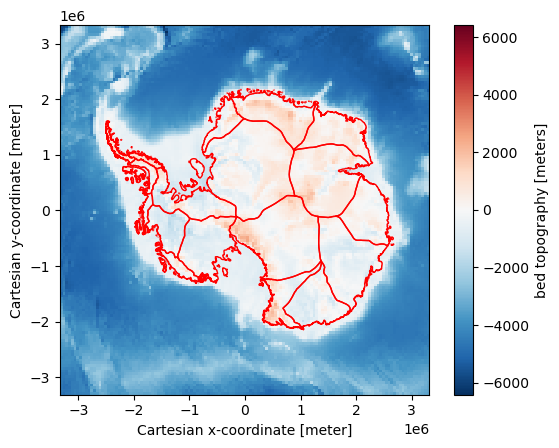
# Construct a simple figure

# Coarsen bed topogrpahy for improved render time
bed = bedmachine_v1.bed.coarsen(x = 100, y = 100, boundary = 'trim').mean()

# Plot bed topography
fig, ax = plt.subplots()
bed.plot(ax=ax)

# Add grounding line
measures_basins_imbie.plot(ax = ax, edgecolor = 'red', facecolor = 'none')
<Axes: xlabel='Cartesian x-coordinate [meter]', ylabel='Cartesian y-coordinate [meter]'>
/g/data/xp65/public/apps/med_conda/envs/analysis3-25.12/lib/python3.11/site-packages/dask/_task_spec.py:758: FutureWarning: In a future version, xarray will not decode the variable 'date' into a timedelta64 dtype based on the presence of a timedelta-like 'units' attribute by default. Instead it will rely on the presence of a timedelta64 'dtype' attribute, which is now xarray's default way of encoding timedelta64 values.
To continue decoding into a timedelta64 dtype, either set `decode_timedelta=True` when opening this dataset, or add the attribute `dtype='timedelta64[ns]'` to this variable on disk.
To opt-in to future behavior, set `decode_timedelta=False`.
  return self.func(*new_argspec, **kwargs)
/g/data/xp65/public/apps/med_conda/envs/analysis3-25.12/lib/python3.11/site-packages/dask/_task_spec.py:758: FutureWarning: In a future version, xarray will not decode the variable 'dt' into a timedelta64 dtype based on the presence of a timedelta-like 'units' attribute by default. Instead it will rely on the presence of a timedelta64 'dtype' attribute, which is now xarray's default way of encoding timedelta64 values.
To continue decoding into a timedelta64 dtype, either set `decode_timedelta=True` when opening this dataset, or add the attribute `dtype='timedelta64[ns]'` to this variable on disk.
To opt-in to future behavior, set `decode_timedelta=False`.
  return self.func(*new_argspec, **kwargs)
# Load composite velocity data
vel_data = catalog.load_dataset('measures_its_live_regional_glacier_and_ice_sheet_surface_velocities', version = 'v1', subdataset = 'ANT', resolution = '240m', static = True)
vel_data
<xarray.Dataset> Size: 25GB
Dimensions:        (y: 18392, x: 22896)
Coordinates:
  * y              (y) float64 147kB 2.26e+06 2.259e+06 ... -2.154e+06
  * x              (x) float64 183kB -2.678e+06 -2.678e+06 ... 2.817e+06
Data variables: (12/14)
    chip_size_max  (y, x) float32 2GB dask.array<chunksize=(144, 358), meta=np.ndarray>
    count          (y, x) float32 2GB dask.array<chunksize=(144, 358), meta=np.ndarray>
    date           (y, x) timedelta64[ns] 3GB dask.array<chunksize=(144, 358), meta=np.ndarray>
    dt             (y, x) timedelta64[ns] 3GB dask.array<chunksize=(144, 358), meta=np.ndarray>
    ice            (y, x) float32 2GB dask.array<chunksize=(288, 358), meta=np.ndarray>
    mapping        float32 4B ...
    ...             ...
    v              (y, x) float32 2GB dask.array<chunksize=(144, 358), meta=np.ndarray>
    v_err          (y, x) float32 2GB dask.array<chunksize=(144, 358), meta=np.ndarray>
    vx             (y, x) float32 2GB dask.array<chunksize=(144, 358), meta=np.ndarray>
    vx_err         (y, x) float32 2GB dask.array<chunksize=(144, 358), meta=np.ndarray>
    vy             (y, x) float32 2GB dask.array<chunksize=(144, 358), meta=np.ndarray>
    vy_err         (y, x) float32 2GB dask.array<chunksize=(144, 358), meta=np.ndarray>
Attributes:
    Conventions:              CF-1.8
    GDAL_AREA_OR_POINT:       Area
    author:                   Alex S. Gardner, JPL/NASA
    date_created:             05-May-2019 15:53:24
    institution:              NASA Jet Propulsion Laboratory (JPL), Californi...
    motion_coordinates:       map
    motion_detection_method:  feature
    scene_pair_type:          optical
    title:                    autoRIFT surface velocities